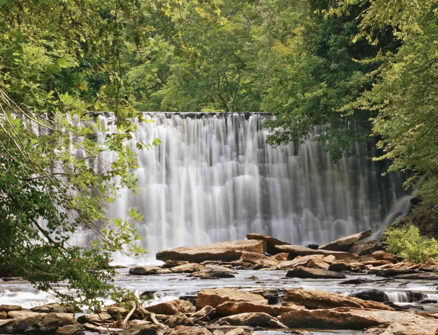

Stand on the wooden covered bridge in downtown Roswell on a quiet morning and you’ll hear the Vickery Creek waterfall before you fully see it: a steady roar rising through the trees, water sheeting over a stone dam that has been here longer than the state of Georgia has had railroads. This is the Vickery Creek Falls, also called the Roswell Mill Falls or Vickery Creek Dam, and it’s one of the most photographed spots in North Fulton for good reason. A tumbling waterfall, Civil War mill ruins, a covered bridge, and miles of shady forest trail, all a short walk from Canton Street.
This is your complete local’s guide to hiking the Roswell waterfall: the trail, the parking, the history that makes it more than just a pretty view, and the one rule change every visitor now needs to know before they go. If you’re building a bigger outdoor itinerary, this pairs naturally with our roundup of the top trails and nature spots in Roswell, where Vickery Creek earns its place at the top of the list.
What to Know Before You Go
Vickery Creek Falls sits inside a larger trail system that’s part of the Chattahoochee River National Recreation Area (CRNRA), managed by the National Park Service, right at the edge of historic downtown Roswell. A few things to get straight up front:
- The waterfall is a dam. It’s a man-made spillway built in the 1800s to power the Roswell mills, which does nothing to diminish how beautiful it is.
- You view it from platforms and trails, not from the water. As of 2024, entering the water at the falls is prohibited (more on that below).
- There’s more than one way in. You can start free from Old Mill Park or pay a small fee at the Riverside Road trailhead.
- It’s a real hike, not a stroll. Expect unpaved dirt, roots, rocks, and rolling hills, with loop options from about 2 miles to 5-plus.
Here’s the quick-reference version:
| Trail Fact | Detail |
|---|---|
| Landmark | Vickery Creek Falls (Roswell Mill dam / waterfall) |
| Trail system | Vickery Creek Unit, Chattahoochee River National Recreation Area |
| Distance | ~2.3-mile short loop up to ~5+ miles |
| Difficulty | Moderate (roots, rocks, rolling hills) |
| Elevation gain | ~295 to 400 feet depending on route |
| Hours | Sunrise to sunset, year-round |
| Dogs | Allowed, leashed |
| Parking | Free at Old Mill Park; small fee at Riverside Rd (NPS) |
| Water access | Prohibited at the falls (since Aug 2024) |
The Story Behind the Falls
The waterfall you see today started as a business decision, and the story behind it is genuinely worth knowing before you visit.
A creek with a Cherokee name. Vickery Creek is named for Sharlot Vickery, a Cherokee woman who lived in what is now Roswell and owned much of the land along its banks. The creek was originally called Cedar Creek, and the name changed to Vickery sometime after Roswell King and his family arrived in the 1830s. Confusingly, you’ll also hear it called Big Creek, a name that stuck after the Civil War. All three names refer to the same water.
The mill that built the town. In 1832, Georgia held a land lottery distributing former Cherokee land north of the Chattahoochee. Roswell King, along with his son Barrington, acquired land here to launch a manufacturing enterprise and the town that would bear his name. The Roswell Manufacturing Company was incorporated in 1839 and became one of the region’s earliest textile operations. To run the machinery, the company dammed the creek, and that spillway dam is the “waterfall” that draws visitors today. Two mills eventually rose beside it, built in 1839 and 1853.
The Civil War chapter. In July 1864, Union forces reached Roswell and burned the mills. What followed is one of the more haunting episodes in local history: the mill workers, most of them women, were charged with treason for producing goods for the Confederacy and deported north by train, many never to return. The story of the “Roswell Mill Women” is still remembered in the community. One of the mills was rebuilt after the war, only to burn again in a 1926 fire and be abandoned. The stone and brick ruins, including the two-story machine shop, still stand on the west bank and are part of what makes this hike feel like walking through a history book.
The Trail: What the Hike Is Actually Like
The Vickery Creek trail network runs roughly five-plus miles through rolling, ferny forest, and it’s flexible: you can knock out a quick loop to the falls or stretch it into a longer trail run.
The route: Most hikers aim for the falls and the covered bridge, then loop back through the mill ruins. From the Old Mill Park side, the path slopes down toward the old machine shop, follows the creek upstream past more ruins, and leads to a viewing platform overlooking the dam waterfall. From the Riverside Road side, you climb into the forest, roll through a series of well-marked and numbered intersections, and spur off to reach the falls from the creek’s bank before crossing the covered bridge.
The terrain: This is a genuine trail, not a paved greenway. Expect an unpaved dirt surface with plenty of exposed roots and rocks, some steady climbs, and stretches that get muddy after rain. Elevation gain runs from about 295 feet on the short loop to around 400 feet on the fuller loops. Sturdy shoes are the right call, and trekking-comfortable ankles will thank you.
The payoffs: Beyond the falls itself, the highlights are the covered bridge (with its rushing-rapid views up and down the creek), the 1850s mill ruins, and the shaded, in-town feel of the whole thing. Wildlife sightings like herons and geese are common along the water. It’s one of the best short adventures in the entire Chattahoochee River park system, even though the trail doesn’t actually follow the main river.
Good to know: Old Mill Park has restrooms and water fountains near the mill building. The Riverside Road trailhead lot does not, though restrooms are available at nearby Riverside Park.
Getting There and Parking
There are a few ways to access Vickery Creek Falls, and which one you choose mostly comes down to whether you want to pay for parking.
Old Mill Park (free). The most popular starting point is Old Mill Park in downtown Roswell, at roughly 95 Mill Street. Parking and admission are free, and you’re immediately next to the mill ruins, the machine shop, restrooms, and the covered bridge. The lot is large but frequently near capacity on weekends, so arrive early or later in the day. There’s a lower lot near the mill building and an upper lot if the first is full.
Riverside Road / Vickery Creek Unit (National Park Service, small fee). The other main trailhead is off Riverside Road, on the northeast corner where Riverside Drive meets Highway 9, just north of the Chattahoochee. This is the National Park Service access point and it charges a small parking fee (recently around $5 per vehicle, though rates change, so bring cash or use an annual Chattahoochee River NRA or America the Beautiful pass). The trailhead lot is easy to miss: after turning onto Riverside Road you’ll cross a small bridge over the creek, and the parking access is right on the other side.
Free alternatives nearby. Some locals park free at Don White Memorial Park across the street from the Riverside lot, or use the Oxbo Trail access, which also offers free parking and connects into the same network.
The Covered Bridge: A Landmark With Its Own Backstory
The wooden covered bridge is the single most photographed feature here, and it’s newer than most visitors assume. Built by the City of Roswell, the bridge was actually constructed in Oregon from Douglas Fir, shipped in two sections, and set in place by crane before being dedicated on September 22, 2004. It’s about 10 feet wide and spans nearly 160 feet, sitting roughly 30 feet above the creek’s normal level to clear the 100-year flood plain, which required a massive concrete retaining wall on one side and anchoring into granite bedrock on the other.
Functionally, the bridge is the connector: it links the walking trails inside Old Mill Park to the National Park Service trails on the far bank. Practically, it’s where you’ll see families and wedding parties lining up for photos on a nice weekend. The upstream view, with Vickery Creek cascading over its rocky bed, is the shot everyone wants.
Important: Water Access at the Falls Is Now Closed
This is the one update every visitor needs before heading out. Effective August 16, 2024, water access at the Vickery Creek and Old Mill Park waterfall was suspended by the City of Roswell. The decision came in response to heavy visitation, environmental strain on the area, and safety concerns. In practical terms: you can no longer climb down into the water or onto the rocks at the falls, and the areas near the water are roped off. Violations can carry fines of up to $250.
The good news is that the trail system remains fully open, and the falls are still very much worth seeing. You view them from designated trails and the wooden viewing platform rather than from creek level. If you visited years ago and remember wading below the dam, know that the experience has changed, and respecting the boundary keeps the spot beautiful and safe for everyone.
Tips for Visiting Vickery Creek Falls
A few local pointers to make the trip better:
- Go early or late. Weekend midmornings get crowded, especially near the falls and bridge. Sunrise and late afternoon are quieter and better for photos.
- Chase the water after rain. The falls are most dramatic when the creek is running high, so a visit a day or two after steady rain rewards you (just expect muddier trails).
- Wear real shoes. Roots, rocks, and mud make flip-flops a bad idea. Trail shoes or sneakers with grip are ideal.
- Bring your dog, on a leash. This is a genuinely great dog-hike, and leashed pups are welcome throughout.
- Pack water and a snack. There’s a viewpoint bench near the dam where a small picnic makes a nice turnaround point.
- Mind the fall foliage. Autumn here is beautiful, but wet leaves can make the rocky sections slick.
- Know it’s family-friendly. The shorter loops work well with kids. For more outings like it, see our guide to family-fun weekends around Roswell.
Make a Day of It in Roswell
One of the best things about Vickery Creek Falls is that it drops you right at the doorstep of historic downtown Roswell. After your hike, Canton Street is a short trip away, with coffee shops, breweries, and some of the best restaurants in the northern suburbs. Our ultimate local’s guide to Canton Street covers where to refuel, and the Roswell Pulse restaurants section keeps a running list of local favorites.
Want to turn the falls into a full outdoor day? String it together with the other riverside routes in our top trails and nature spots in Roswell guide, or if you’re new to the area entirely, start with our overview of visiting Roswell, Georgia and why all the hype around Roswell is well deserved.
Final Thoughts on Hiking the Roswell Waterfall
Vickery Creek Falls is that rare landmark that delivers on every front: it’s genuinely scenic, steeped in real history, easy to reach, and flexible enough for a quick loop or a proper trail workout. Come for the waterfall, stay for the covered bridge and the mill ruins, and remember to enjoy it from the trails and platforms rather than the water. Show up early, wear the right shoes, and give yourself time to wander the ruins. Then walk it off with a coffee or a burger on Canton Street. That’s a perfect Roswell morning.
Planning a hike or a weekend in town? Explore more local guides across Roswell Pulse, your source for everything Roswell, Georgia.